
On June 28, 2025, Joe Miller set out from Lakeview, Oregon, for an 11-day backcountry bicycle tour on the Adventure Route of the Oregon Timber Trail (OTT). 553 miles and 42,400 feet of climbing later, he rode into Hood River, Oregon—battered and beaten, but ecstatic about his experience.
For those of you interested in taking on this epic trail, we’ll be sharing Joe’s story over the coming weeks, which includes his reflections along the way as well as several tips.
Joe Miller is a Board Member of the Oregon Timber Trail Alliance (OTTA), as well as an outdoor advocate and volunteer who has spent the past 30 years exploring the Pacific Northwest backcountry by foot, ski, raft, and bike.
Day 11:Gibson Horse Camp to Hood River
Link to Ride With GPS for this section: https://ridewithgps.com/trips/305596520
| Total Mileage | 45.7 |
|---|---|
| Elevation Gain / Loss | +3,073 / −6,775 |
| Max Grade | 13.5% |
| Total Duration | 6:22 |
| Moving Time | 4:51 |
| Stopped Time | 1:30 |
| Cumulative Mileage | 582.8 |
| Cumulative Elevation Gain / Loss | +42,662 / −46,851 |
| Average per Day (Days 1 – 11): 52.98 mi / +3,878 ft / −4,259 ft | |

Ride Report
There isn’t much at Gibson Horse Camp, so after a quick breakfast I packed up and got on the bike, anxious to roll into Hood River with the accomplishment of finishing this ride. Right out of the campground is a 14-mile descent on pavement and good gravel into Parkdale. I enjoyed rolling through the bucolic countryside of orchards before stopping at the grocery store, and even though it was early in the ride, decided to have lunch in the shade at a park across the street.
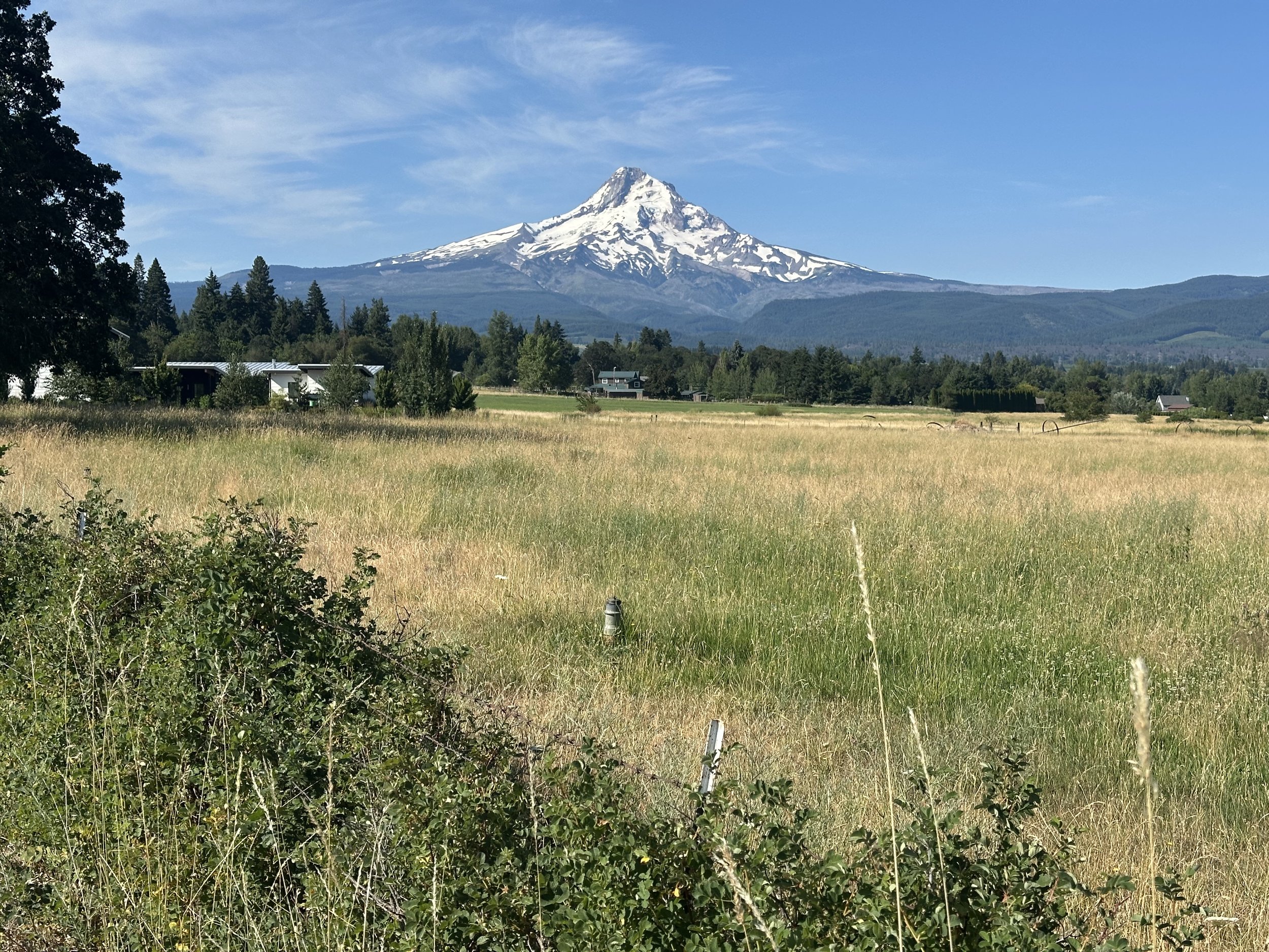
The scenery is truly lovely around Parkdale. Enjoy the flats through here, it turns upwards shortly after leaving Parkdale.
The route pleasantly winds its way through the Parkdale agricultural areas, and 24 miles into the day’s ride, the climbing starts in earnest up to Kingsley Reservoir. This climb is 7 miles long and ascends about 2,250 feet on pavement—butter gravel to rice and beans gravel—transitioning through those various surfaces up to the reservoir. The statistics obscure the reality of the difficulty, as this is a very steep climb. One section is 2 miles long with 1,000 feet of climbing and the remaining segments peak at 17-18% according to my Garmin. The road surface is better than the previous two days, but the steepness makes up for those shortcomings.

Take in the views while you can. I lost interest in photography on this climb, but the views are incredible
Once at the top, I collapsed in the shade near the reservoir to eat some snacks and finish the rest of my water before the descent. I celebrated finishing the big climbs for the day and was anxious to roll into Hood River to dip my tires in the Columbia, but the route would continue to present challenges for me. The descent from Kingsley Reservoir was just as steep as the climb up and it would be a bad place for a spill. Since I was so close to completing the route, I stayed on the brakes. I opened it up where it was safe, but otherwise I had the brakes buried and the cables stretched tight. One section was so steep that I couldn't stop just by using the brakes, so I went for the ditch and dragged my foot until I got my speed under control and could stop. After the past two days of rough descent, my brakes had had enough and got overheated before failing. Once I stopped, I let the brakes cool down, tightened up the cables and continued on my way down into Hood River, finally reaching pavement about 40 miles into the day. The route meanders through the upper agricultural areas of Hood River before continuing on to a local pedestrian trail for the final three miles into downtown Hood River. Crossing over I-84, the route finally concludes at the beach on the Columbia River.
I dipped my tires, took the obligatory selfie, and waded into the river before heading over to Pfriem Brewery for a few celebratory beers and lunch. Fortunately, I finished the day at about 3:00 and the last Columbia Gorge Express bus leaves for Portland at 5:30. So, I was able to slowly enjoy the beer and food before remounting my bike and riding the 15 minutes to the bus depot. A $10 ticket will get you a ride to the Gateway Transit Station in Portland, which is just a few TriMet stops from the airport. For me, it's another 16 miles across town to my house, which I took at a leisurely pace on familiar bike routes. I finally got home at 8:30 that evening, happy to be back in my own bed.
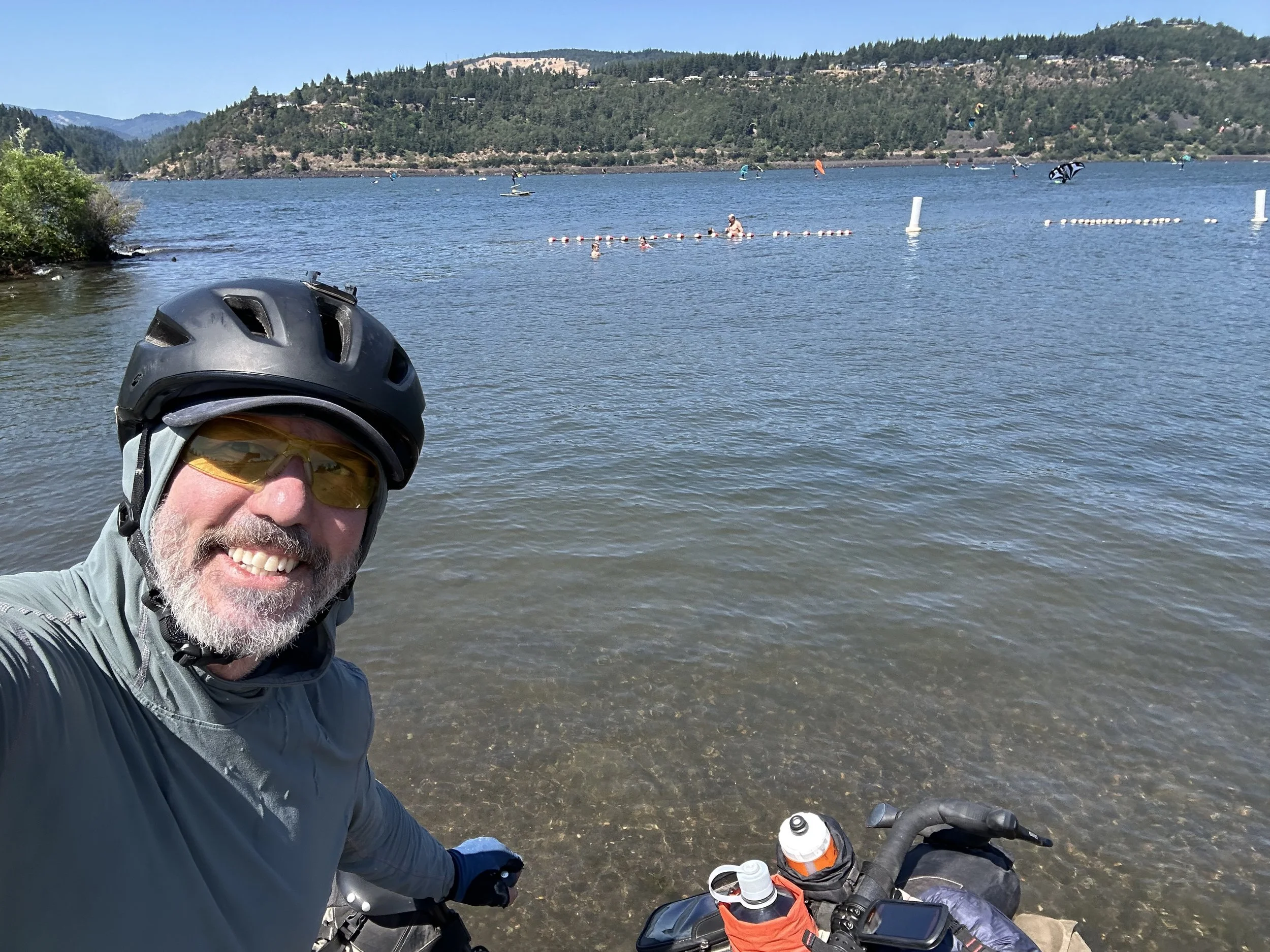
And...Done! The Columbia River was a delight to see, even if I had to ride my bike through more sand to get to the water.

Conveniently enough, the Pfriem Brewery is right at the finish. I won't say how many of these I had, but the pain was gone by the time I left.
Conclusions
Lots of people have asked me if I would do this ride again, and I always answer with a resounding "YES." Even right after I finished, and I was at peak suffering, I was a yes. It's a great route, an accessible adventure that is within reach of most people who enjoy this kind of thing. It's certainly not a beginner route, but it's also not so hard that only the super dedicated fitness fanatics can complete it. I have a decent level of base fitness, and I completed a few long training rides in preparation for this ride; however, I did not train for it as I would have if I were racing or trying to set a personal best. If you have enough time, and the body and/or bike doesn’t break, the only limiting factor is willpower. I think the best training one could do for this is to go into challenging, uncomfortable, and remote terrain for a few days. If you enjoy that, you'll love this route.
I enjoyed the first four days of the ride the most, in no small part because I had a great riding partner in Hanna. The area between Lakeview and Chemult is unique and seldom visited, and I recommend doing some research on the area's history before visiting. It'll put the landscape into a more enlightened perspective. The people we met along the way were friendly and made us feel welcome. Everyone was quick to offer a helping hand. This ride, and the first four days in particular, restored my faith. People are generally good and caring and want to help each other, even in these times of vast political differences.
As to the route, I would not change a thing. It was hard but not so challenging that I didn't have fun or felt like I wouldn't be able to finish it. It was technical for a gravel bike; suspension would make it safer and a lot more fun. The sand on the Old Santiam Wagon Road is a drag, but bigger tires make it navigable. I'd fatten up to a 2.3 next time and run a lower tire pressure.
Lastly, prepare yourself for the Hood Tier, where the climbing really begins. The climb to Olallie Lake is rough, but fortunately, once at the pass, there is Breitenbush Lake and plenty of other camping options to make for a shorter day.
If you have any questions or want some insight for the ride, feel free to contact me at joe.miller@oregontimbertrail.org.
Basic Necessities
Water
Fill up water in Parkdale, and there are plenty of sources on the climb over to Hood River.
Camping options:
You can camp in Parkdale, not many options past that and you’re really close to being finished.
Resupply options
Parkdale Grocery Store
Route:
The climb up to the reservoir broke me. From the elevation profile, it didn’t appear to be too demanding, but by that point my knees ached, my quads burned, and my ass was ready for a change of scenery. I was glad to be done.
The descent into Hood River is steep. Check your breaks before Parkdale and consider changing out the pads. My brakes got hot and failed on the descent as I tried to stop. They will have taken a lot of abuse, treat them well.
